I don't often say this, but if you're a runner with a bit of feeling for the fells, then this is a race you should definitely do at least once in your career.
I can't really remember when I entered the Lakes Sky Ultra. I think it must have been back in the autumn of last year when I still had realistic Dragon's Back ambitions because when I got the reminder email with the final details around three weeks ago it did seem quite a big undertaking in the light of all the problems I'd had this year. Still, I'd paid so I decided to go and give it a shot; the best I could hope for was to get round the course within the time allowed, so I planned for that and in the end that's what happened. 72nd place out of 73 finishers doesn't sound too great (although out of 100 starters it sounds slightly better), but all round it turned out a very satisfying day out, certainly my best effort for 2017 so far.
Most Race Directors are guilty of a touch of exaggeration in their advertising but as Charlie Sproson is one of the few people to have completed a Ramsay Round so must know his way round a hill or two, I think you have to take notice when he describes his race as
"........one of the spiciest races in the country. 56km of Lakeland paths, trails and tussock, 4500m of vertical grind, grade III scrambles and knife edge arêtes - this race has it all. It is not for the faint hearted and racers will need to be competent on steep rock scrambling sections. It is extreme. It is gnarly. It is hardcore. It is awesome."
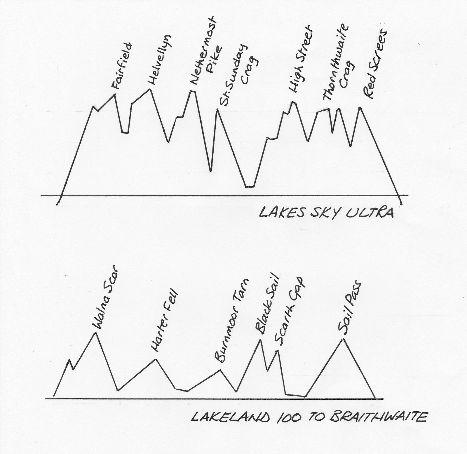
A rough profile is shown below, with another of the first 52km of the Lakeland 100 on the same scales for comparison. You can see that 4500m (14,700ft) means a fair bit of up and down.
On the application form we had to confirm that we had the scrambling ability to complete the course, promise not to fall off anything steep into embarassing places, and to exercise "sound mountain judgement" should the need arise. We also had to declare we were fit enough in wind and limb to take on the course. I wasn't too sure about this one but I'd decided after the West Highland Way that the best way to treat my knee was to ignore it, taking heed of the Joss Naylor advice that "if something ails you, you've just got to shrug it off or you won't achieve much in the hills". I'm sort of getting used to the discomfort now anyway, so I guessed it would probably be OK. Three days after the event it's a still bit swollen and sore but nothing disastrous, so with some rationing and careful planning I think it will see me through a year or two more running yet.
Registration was on the Friday evening at the University of Cumbria's Ambleside site, which was also the start and finish point for the event. After the normal kit check and picking up of dibbers, trackers and everything else that seems to complicate races these days, a meal was available followed by a compulsory briefing in the lecture theatre. Charlie showed us videos of the first running in 2015 (it rained a lot) and the second last year (it was sunny), and said that everyone was doing too many races these days because at least 40 entrants had withdrawn before the start due to injuries; nevertheless we would be a select field of around a hundred runners. He told us to look after ourselves and each other and have fun, and finished with the weather forecast which ended with the phrase "sunshine is unlikely".
A civilised start time the following morning meant that I didn't have to leave Keswick until well after 6am after a proper breakfast, so was nicely set up for the day. We gathered under very low cloud for the countdown and were off on the dot of 7am. Everyone started off running up the hill (pretty well any direction out of Ambleside is uphill) so within two or three minutes I was established firmly at the rear with fifty or so yards gap between me and the back of the pack; I don't often run up hills, especially not first thing in the morning, but I wasn't bothered, I knew most of the ground ahead and I had a plan for (just) getting round in time. At the first gate I stopped to say hello to Karen Nash, who I knew from Facebook but had never met; she was supposed to be running but was one of those who had unfortunately had to pull out through an injury. After that, everyone else was out of sight, having disappeared into the mist ahead.
I have to admit that the weather on the day wasn't great. Visibility generally fluctuated between twenty and about a hundred meters; we had heavy rain at times and some dry spells but the overall impression was of a steady drizzle, made a bit more wet by the fairly constant wind that meant that my main audible memory of the day was the continual ripping of the wind at the race number pinned to my leg. Not an unusual day for the Lakes though, "if you can't take a joke you shouldn't have come" sort of weather.
The thing started with an ascent of the eastern arm of the Fairfield Horseshoe, from Ambleside up to Fairfield summit. I've covered this ground at least a half dozen times up and down over the years but there are lots of choices on which side of the wall to go where, which path to use when there are choices even on one side, etc, and I have to say the line the race took was the best I've ever used. How did we follow this line?....because the course was fully marked as are all "Sky Running" events. I'm always in two minds about this; it somehow seems wrong to have all the navigation done for you when out on the hills and it certainly takes away any compensation that slower runners might gain by being better navigators, but it also takes away some of the "home advantage" locals might have from knowing the ground. Today however there was a slight problem. The markers (normally small red flags on thin metal "wands" stuck in the ground, rocks, fence posts, etc) are normally placed at about 20 - 50 metre spacing depending on the terrain, which meant that because of the mist there were many occasions when you arrived at a flag but couldn't see the next one. This was OK when following an obvious track or ridge, but a bit disconcerting when the line just ploughed off across country with no other markings. I think that probably slowed everyone down to some extent but with a bit of care it worked well enough.
I walked the steeper uphills and jogged the rest up to the first checkpoint on Dove Crag, by which time I had overtaken four runners so was now not actually last. I told the lonely looking marshal that she wouldn't have to stay up there much longer, then pressed on over Hart Crag and Fairfield, then down the quick descent to checkpoint 2 at Grisedale Hause. The route then followed the Bob Graham line around the west side of Grisedale Tarn and up the steep grassy trod to the well-known lonely fence post on the track just short of Dollywagon Pike. Halfway up here a photographer appeared out of the mist, an event that was repeated in all sorts of unlikely spots throughout the day.
Along the track towards Helvellyn I caught up with another runner and we carried on together for a mile or so. He told me that he was a bit impressed with the class of the field; he said he'd been in a race down in South Wales a couple of weeks previously where he had come second in a field of over two hundred, now here he was in the last half dozen of a hundred! We passed the filming team on Helvellyn (like you do) and set off on the first bit of fun for the day, down Swirral Edge and along to Catsty Cam. "Now the flags will be along the crests of the ridges" RD Charlie had told us at the briefing, "and that's where you go. No going down onto to the granny tracks along the sides!" He wasn't wrong; throughout the day, if there was a crest to be found, that's where the line went. The greasy condition of the rocks needed a bit of care but we seemed to be making quick enough progress. We checked in with another chilly-looking marshal on Catsty Cam (these guys all did a sterling job in the conditions, especially later in the course where they were out for much longer), then followed a knee-testing descent down the west ridge to the old dam in Keppel Cove. There was another checkpoint here which had water, so I stopped to top up a bottle. I reached here three and a quarter hours from the start, the marshal said the leaders had been through an hour and a quarter earlier, so the field was starting to spread out now. With such poor visibility we had really no awareness of where anyone outside our little bubble was on the course.
A traversing line following a sort of path led westwards round to Red Tarn Beck, then it was straight up the grassy fellside to the "hole in the wall", another checkpoint and a well-known landmark on the approaches to Helvellyn from Patterdale. Striding Edge next, which as most of the moves were uphill or horizontal could be taken at a faster pace than the descent of Swirral in the prevailing conditions.
 |
Striding Edge (all photos in this post are taken from the Lakes Sky Ultra
Facebook page, just to give an impression of atmosphere on the day.I don't
know who the individual runners pictured are)
|
I caught up with three ladies on the last few hundred feet, then as we popped out onto the summit plateau again we immediately lost the flag line. We knew we were heading for Nethermost Pike so turned left and kept moving. I explored a bit down towards the edge and found the flags again, along an almost sheltered little trod a bit down from the top. We slowed down a bit to avoid losing them again. Just before Nethermost one or two yellow flags started appearing in between the red ones. On the summit checkpoint the marshal (the famous John Bamber of Gregs Hut on the Spine Race) explained that he had brought yellow flags up to mark the dibber point, but it in the conditions he found when arriving on the summit you couldn't see from one red flag to the next so he had used them to make the line a bit easier to follow; I think all the runners will have appreciated that, especially on the next section which was finding the start of a little-used descent down the east ridge of Nethermost to the top of Eagle Crag.
This started off down a steepish rocky ridge but this gave way to grass at an easier angle with good running for a while. The girls got away from me down here but I caught them again as they stopped to tighten shoe laces before the steep descent alongside Eagle Crag. I was happy with mine so pressed on through, first down a rocky gulley then some very steep grass and finally a rocky corner leading to the scree below the crag. There were two or three marshals in this area and they had rigged a knotted rope down the corner which in the slippery conditions was welcome.
I had pondered shoe choice for quite a while before the race. I've been using Innovate Roclites for more technical rocky ground recently and they seem very nimble, but don't really have enough cushioning for me to wear all day. The entry rules for the race specified a lug depth of at least 3mm so I guessed there must be some steep grass in places. In the end for the first half of the race I wore Scott Kinabalu Supertracs which have a good grass/mud grip and are very comfortable. You needed care on the wet rock with any shoes so their deficiencies on that score were not too much of a handicap on the day and I was happy with the choice.
 |
| Descending past Eagle Crag
Dropping out of the mist below Eagle crag we met with the best weather conditions of the day. Suddenly you could see right down the valley to Ullswater below. On the other hand, you could also see the next bit of the course with many runners strung out on it. After crossing Grisedale Beck at the big footbridge we were faced with a climb of around twelve hundred feet up extremely steep pathless grass to the base of Pinnacle Ridge on St Sunday Crag. A lot of techniques were in evidence, some runners taking it in manic short bursts followed by gasping rests, others taking it very slowly and steadily, some trying to use poles but it was really far too steep for them to be any use. The most effective for me seemed to be to walk up steadily, hands on knees on the less steep bits and grabbing the bilberries for a quick pull on the steeper sections. I resisted the temptation to look up too often and the base of the crag seemed to arrive soon enough. There were marshals at the base of Pinnacle Ridge and at various points along it. The rocks were greasy in places but less than I had expected. At the briefing we had been told that the steep crux corner would be in the course but when we got there the marshals had us avoiding it via a fixed rope up some steepish grass around to the left. Whether this was down to changing conditions or some other reason I never found out. I reached the top of the crag about 45 minutes after crossing Grizedale Beck and was relatively pleased with that.
|
 |
| Pinnacle Ridge |
From St Sunday Crag it was a very cruisy couple of miles or so down a nice grassy track to the halfway checkpoint in Side Barn at Patterdale, with the last ten minutes or so in the "unlikely" warm sunshine.
The overall time allowed for the event was 14 hours, ie for a 9pm finish. Patterdale was pretty well exactly half way in distance but the first half contains far more climbing and technical ground so the cut-off here was set at seven and three quarter hours; I had hoped to arrive in seven but was about six minutes over that. In dry conditions with good visibility I'm sure I could have knocked at least half an hour off that, so I was happy enough with progress so far. I just needed not to hang around too much from here on.
Patterdale had coffee and soup, bread and biscuits, all very welcome after seven hours fairly hard work. You also had a drop bag opportunity here, so I put on a dry shirt and changed my shoes and socks. I didn't expect anything too steep over the second half of the course, more traditional Lakeland paths rather than cross-country terrain so I went with my favourite Skechers GoRun Ultra shoes; Hoka-like comfort but with great grip on rock, wet or dry (but also pretty useless on steep grass). I also picked up my poles which I had felt would only get in the way on the first half but might be a good aid for tiring legs over the second half. I left Patterdale after a twenty minute stop, probably a bit indulgent but it meant I set out feeling in good shape and ready for the second half of the day.
We lost the good weather almost immediately, by Boredale Hause we were back in the clag and it stayed that way for the rest of the day, now accompanied by more frequent and heavier periods of rain.
The easy track made for rapid progress along the "Coast to Coast" route past Angle Tarn and round The Knott to the flank of Kidsty Pike. I was power walking the steeper bits and jogging the rest, and I passed several other runners along this section. High Street was bleak. The route left the main track just before the summit and set off across the fellside to look for a descent down Long Stile ridge to the west. The rain was hammering at this point and it was very difficult spotting each flag from the previous one. I had put a trace of the route into my Suunto watch and was just about to fire it up when the start of the ridge appeared and navigation became simple again. The ridge had rocky steps but the route left it after a few hundred feet to cut down across the grass to the outflow of Blea Water, and from there down an easy track to a checkpoint at Mardale head, reminiscent of "Lakeland 100" visits.
Another longish climb followed, up past Small Water to Nan Bield pass and then following the Kentmere Horseshoe track up to Mardale Ill Bell. Flat ground now, still searching for the elusive red flags in the gloom, along to Thornthwaite Crag where eventually the familiar tall tower emerged out of the mist when I was barely twenty yards from it. I knew from previous visits that there was a deep, rocky gap to get from here to Stoney Cove Pike because it figures on the Joss Naylor Challenge, but somehow today it didn't seem too daunting. Once on top of the Pike however a glance at the watch revealed that I didn't have too much time to spare to make the 7.15pm cut-off at Kirkstone Pass, so the couple of miles down the easy grass here were probably my fastest of the day. I caught half a dozen more runners just before the road and we made it with over ten minutes to spare, speculating whether this was actually a bit tight or simply good pace judgement. "Lots of time left yet!" was the marshal's verdict.
The six or seven of us set out on the last leg more or less together. Now there is a really nice path from Kirkstone to the top of Red Screes; a few manufactured steps, a bit of easy scrambling, a nice track up the grass to finish. But RD Charlie was having none of this and a hundred yards from the road the flags left the path and headed out rightwards, to find a way up steep grass, collapsing muddy trods, greasy little gulleys and various other forms of God Wot, to emerge back on the track just a few steps from the summit. The term "masochist" was heard in the conversation more than once, but all was forgiven as we heard the sound of the cowbell announcing the marshals on the summit. Her words to me as I made the last "dib" were "It's downhill all the way from here and you've more than enough time to finish, the world is rosey!"
The others went haring off but I really was in no hurry now. I like to enjoy the run-in on these days out if there is no time pressure, so I jogged steadily down the easy but squelchy three miles back to Ambleside in probably the heaviest rain of the day.
I finished in 13:42:17, nicely inside the 14 hour limit in the end. A great day out over a pretty spectacular course.
Would I go again? Well, I would love to have a trip round in good weather when it would be even better, but 2018 will be time for my bi-annual rendezvous with the Lakeland 100 and the two events are too close together for an old dodderer like me to manage both. After that, I'll see. Never say never, as they say.
Lots of thanks to the organisers and marshals who put on a super event in less than perfect conditions. Without you, we couldn't have the fun that we do.
(If you're interested, there is quite an atmospheric little video here made on the day by a competitor in a similar position to me in the field for most of the day).